
The very severe cyclonic storm ‘Biparjoy’ intensified into an “extremely severe cyclonic storm” and is likely to make landfall near Mandvi-Jakhau Port along the Saurashtra-Kutch coasts.
In view of the impending landfall and the storm, Gujarat has been placed on high alert. On June 14, IMD has declared an orange alert for all districts, while on June 15 a red alert has been issued across the state.
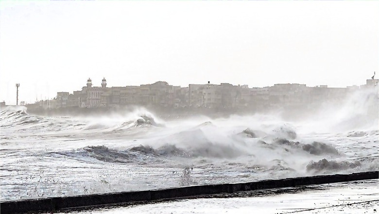
On Thursday, the cyclone is expected to be the strongest, and this would lead to extremely heavy rainfall in coastal areas of Gujarat, IMD Director General, Mrutyunjay Mohapatra said.
The rainfall will especially hit on the coastal areas of Gujarat. This could lead to inundation of coastal and low-lying areas. As the cyclonic will give way to very gusty winds, some damage to tin houses, electrical lines could be seen.
#WATCH | IMD Director General, Mrutyunjay Mohapatra speaks on Cyclone Biparjoy, says, “We have issued an Orange alert for June 14 and a Red alert for June 15 for all districts. From June 15 we will see a landfall in it and will move towards the north-northeast (NNE) direction. We… pic.twitter.com/Krn3EVbSGD— ANI (@ANI) June 12, 2023
Meanwhile, Minister Narendra Modi held a meeting to review the situation related to Cyclone Biparjoy today, while authorities have started evacuating people in districts by the sea in view of the cyclone. The landfall is predicted on the evening of June 14.
As the Gujarat administration braces for cyclone ‘Biparjoy’, the Kutch district on Monday imposed section 144 in coastal villages, where the cyclone will have a severe effect.
In its latest bulletin, the India Meteorological Department (IMD) said the ‘extremely severe cyclonic storm’ was very likely to move north-northeast and cross Saurashtra and Kutch and adjoining Pakistan coasts between Mandvi (Gujarat) and Karachi (Pakistan) by the noon of June 15 as a ‘very severe cyclonic storm’ with maximum sustained wind speed of 125-135 kilometres per hours (kmph) gusting to 150 kmph.
Due to cyclonic activities, sea conditions along and off Saurashtra and Kutch coasts will likely remain “rough to very rough” till Wednesday, and very rough to high on Thursday, IMD said.
High tidal waves and rainfall were also witnessed in Mumbai as Biparjoy intensified into a severe cyclonic storm.
IMD Advises For Total Suspension of Fishing Operations
The weather agency has advised total suspension of fishing operations in the region till June 15 and has asked fishermen to not venture into the central Arabian sea, north Arabian sea during June 12-15, and along and off Saurashtra-Kutch coasts till June 15. IMD also advised those out at sea to return to the coast and regulate offshore and onshore activities judiciously.
“In view of the above, the state governments are advised to keep a close watch, monitor the situation in their areas regularly and take appropriate precautionary measures. District authorities are advised accordingly,” the IMD said.
Cyclone ‘Biparjoy’ Movement
At 4:30 pm on Sunday, the extremely severe cyclonic storm “Biparjoy” over east central Arabian Sea moved northeastward with a speed of 8 kmph.
It lays centred about 550 km west of Mumbai, 450 km south-southwest of Porbandar, 490 km south-southwest of Dwarka and 570 km south-southwest of Naliya in Kutch and 750 km south of Karachi in Pakistan, the Met department said.
“It is very likely to cross Saurashtra and Kutch and adjoining Pakistan coasts between Mandvi (Gujarat) and Karachi (Pakistan) by noon on June 15 as a very severe cyclonic storm with a maximum sustained wind speed of 125-135 kmph gusting to 150 kmph,” IMD said.
A cyclone moving over the land after its intensification in the ocean is said to make landfall when the centre of the storm (eye) moves across the coast.
Wide-Scale Destruction Expected In Gujarat
Several districts of Gujarat, including Kutch, Devbhumi Dwarka, Porbandar, Jamnagar, Morbi, Junagarh, and Rajkot, may face damages on June 15.
Expected destruction includes the demolition of thatched and kutcha houses, damage to pucca houses, uprooting of power and communication poles, and potential threats from flying objects, according to a report by the news agency IANS.
Further, transportation systems may be disrupted; and extensive damage to crops, plantations, and orchards is expected. The visibility in these areas will be severely impacted, and small boats and crafts may be at risk.
Indian Railways has also implemented various measures to ensure the safety and minimise the impact of the cyclone.
Measures Taken By Gujarat Govt
The Gujarat government is deploying NDRF and SDRF teams in coastal areas and will set up shelters in six districts before the extremely severe cyclonic storm Biparjoy makes landfall on the state coast.
Chief Minister Bhupendra Patel has delegated the task of advance planning and disaster management to senior ministers of the state cabinet. These ministers will provide guidance and support to the district systems.
The assigned ministers are as follows: Rishikesh Patel for Kutch District, Praful Bhai Pansheriya and Kanubhai Desai for Morbi, Raghavji Patel for Rajkot District, Kuvarji Bavaliya for Porbandar, Mulu Bhai Bera for Jamnagar District, Harsh Sanghavi for Devbhumi Dwarka, Jagadish Vishwakarma for Junagadh District, and Purushottam Solanki for Gir Somnath. Chief Minister Bhupendra Patel has instructed all these ministers to promptly reach their respective districts.
Teams of the National Disaster Response Force (NDRF) and State Disaster Response Force (SDRF) are being deployed along the coastal areas and various departments including fisheries, health and agriculture have been asked to work in coordination, according to Relief Commissioner Alok Pandey.
The government will set up shelter houses in the six districts for those residing within a 5-10 km radius of the coastline who will be shifted to safer places.
Union Home Secretary Ajay Bhalla on Sunday also reviewed the preparedness of different wings of the central government and the Gujarat administration to deal with the impending Cyclone Biparjoy.
Impact on Weather
The IMD has issued heavy rainfall warnings for Kutch, Devbhumi Dwarka, Porbandar, Jamnagar, Rajkot, Junagadh and Morbi districts on June 14 and 15.
On June 14, the intensity of rainfall is likely to increase to “heavy to very heavy ” in a few places and “extremely heavy ” at isolated places over the affected districts on June 15. The remaining districts of Saurashtra and north Gujarat regions are also likely to witness very heavy rainfall on that day, the IMD bulletin said.
In view of inclement weather conditions due to Cyclone ‘Biparjoy’, a runway at Mumbai airport was closed, leading to the cancellation and delay of some flights.
Also Read: Chaos at Mumbai Airport as Main Runway Closure Due to Bad Weather Hits Flight Operations
IMD Forecast of the Rest of India for the Next 4 Days
Northeast India: Widespread light to moderate rainfall with isolated heavy to very heavy falls very likely over the region during the next four days, IMD said in its latest bulletin.
East India: As per the weather agency, heavy rainfall is very likely at isolated places over Sub-Himalayan West Bengal and Sikkim during the next 36 hours and heavy to very heavy rainfall during the subsequent three days.
Heavy rainfall is also very likely at isolated places over Andaman and Nicobar Islands during the next three days.
Northwest India: Hailstorms are very likely at isolated places over Himachal Pradesh and Uttarakhand during the three to four days. Severe thunderstorms with squalls are very likely over isolated parts of Rajasthan on June 15.
West India: Heavy rainfall is very likely at isolated places over Konkan and Goa today and over Gujarat Region on June 15.
Heavy to very heavy rainfall is also very likely at isolated places over Saurashtra and Kutch on June 14 and extremely heavy rainfall on June 15.
South India: Heavy rainfall is very likely at isolated places over Kerala during the next 36 hours and over Coastal Karnataka today.
Heatwave warning: Heatwave conditions are very likely to continue in isolated pockets over Bihar, Jharkhand and Coastal Andhra Pradesh during the next four days, and over south Haryana-Delhi, south Uttar Pradesh, Gangetic West Bengal and Odisha from till June 13.
Heatwave conditions are also likely over Sub Himalayan West Bengal, Vidarbha, Chhattisgarh and Telangana today.
Hot and humid conditions are very likely over Tamil Nadu, Rayalaseema, Madhya Maharashtra and Marathwada during the next two days.


Comments
0 comment