
India is set to experience the driest August in the past 123 years, which senior meteorologists say, is a clear result of intensifying El Nino conditions.
The country received a record rainfall of 115.4 millimetres in the first 21 days of the month, breaking the previous record of 190.1 mm in 2005.
With the deficit rainfall this month, the country is poised to experience the driest August since 1901 and driest monsoon since 2015, which recorded a rainfall deficit of 13 percent.
Driest August since 1901
In August, the country received 254.9 mm of rainfall, accounting for around 30 percent of the precipitation during the monsoon season.
The country has seen rainfall deficit of 32 percent this month and the prediction for next few days shows the absence of precipitation making it the driest August since 1901, an India Meteorological Department (IMD) official said.
India had recorded a rainfall deficit of 25 percent in August 2005, 24.6 percent in 1965; 24.4 per cent in 1920; 24.1 percent in 2009 and 24 percent deficit in 1913, news agency PTI quoted IMD data as saying.
Reason Behind Record Deficit
IMD chief Mrutyunjay Mohapatra said the primary reason for below-normal rainfall in August are El Nino — the warming of waters in the Pacific Ocean near South America — and the “unfavourable phase of the Madden Julian Oscillation (MJO) which is known to reduce convection in the Bay of Bengal and the Arabian Sea”.
El Nino is generally associated with the weakening monsoon winds and dry weather in India. The MJO is a large-scale intraseasonal atmospheric disturbance originating in tropical Africa and travelling eastwards. It is like a pulse or wave lasting about 30 to 60 days.
During the active phase of the MJO, the atmosphere becomes more favourable for rainfall. This leads to increased cloud cover, stronger winds, and enhanced convective activity, resulting in heavier rainfall over the Indian subcontinent. In July, the country recorded above-normal rainfall due to the favourable phase of MJO.
Another reason for below-normal rainfall in August was a lower number of low-pressure systems in the South China Sea and they, too, moved northward, an IMD official said.
India experienced the longest break in the monsoon — from August 6 to August 17 — since 2009 which recorded 13 such days as El Nino gathered strength. The El Nino phenomenon that developed in July and affected rainfall in August, will turn moderate in September and remain strong till December.
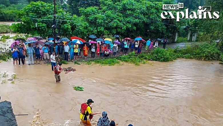
Rishikesh India’s wettest town
For the month of August, Cherrapunji and Mawsynram, which holds record for being the wettest places in India and the world, was not the wettest town in the country.
Rishikesh in Uttarakhand broke the record for the month of August as it received 1,901 millimetres of rainfall till August 25, according to a report in Down To Earth.
Meanwhile, Cherrapunji and Mawsynram, received 1,876.3 mm and 1,464 mm rainfall respectively, the report added.
Rishikesh received over 400 mm rainfall twice in August- on August 10 and then on August 13. The extremely heavy rains in Rishikesh caused significant flooding and the Ganga River flowed above its danger mark for many days this month, threatening the people in the Himalayan town.
Erratic Monsoon
India is on course to end the June-September monsoon season with a rainfall deficit of at least 8 percent, which would be the widest since 2015, when El Niño also curtailed precipitation.
In its last full-season forecast, on May 26, the IMD had anticipated a rainfall deficit of 4% for the season, assuming limited impact from the El Niño weather pattern.
With the driest August in more than a century, the current monsoon has been uneven, with June rains 9 percent below average and July rains rebounding to 13 percet above average.
The southwest monsoon will begin withdrawing from northwestern India on time or slightly before the normal date of September 17. The last four Septembers have seen above-average rains due to delayed withdrawal of the monsoon. The September rain is key for winter-sown crops such as wheat, rapeseed and chickpeas.
(With inputs from agencies)


Comments
0 comment