
Geoguessr Tips & Tricks
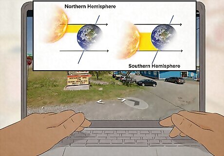
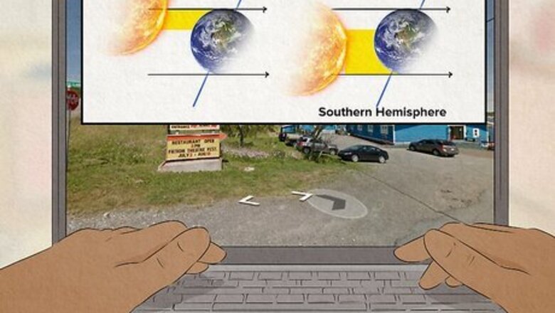
Find the sun to figure out what hemisphere you’re in. Use the compass in the bottom right corner to find which part of the sky the sun is in. If the sun is in the southern half of the sky, you’re in the northern hemisphere. If the sun is in the northern part, you’re in the southern hemisphere. Additionally, look at the plants and climate to see which part of the world you might be in. If you’re in the southern hemisphere with reddish soil and desert plants, you may be in Australia.
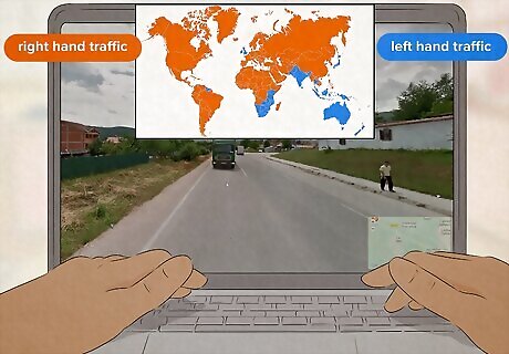
Look at which side of the road that cars are driving on. Only 30% of countries in the world use left-hand traffic rules. If the camera or the other cars are driving along the left side of the road, you can limit your guess to countries captured by Google Street View that use left-hand traffic rules. These countries include: Australia, Bangladesh, Bhutan, Botswana, Christmas Island, Eswatini, India, Indonesia, Japan, Jersey, Kenya, Lesotho, Malaysia, Malta, South Africa, Uganda, Singapore, Sri Lanka, Thailand, Ireland, Isle of Man, United Kingdom, Virgin Islands, and New Zealand.

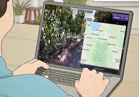
Use the compass to find the directions of landmarks. If you notice a mountain range, coastline, river, city skyline, or any other landmark that might appear on a map, turn towards it and take note of the direction. When plotting your guess, this allows you to find where you are based on the direction of other landmarks around you. For example, if you see an ocean south of you and a river to the east, look at the map and find a spot where the ocean is just south and the river is slightly east.
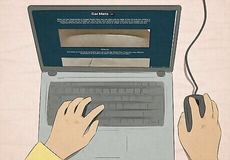
Look at the type of Google Street View car and camera used. Most Google Street View vehicles are blurred out, but when you move your camera downwards you might see the vehicle’s color, shape, or shadow. From this blur, you can narrow down the country you might be in. For example, if the camera is mounted low with a large vehicle blur, you’re in India, Japan, Sri Lanka, or Switzerland. If the car is black with an antenna on the back, you’re probably in Russia, Donetsk, Israel, or Palestine. If the car is red, you’re in Ukraine, Belgium, or Russia. Use this tool to identify the country you’re in by looking at the shape and color of the Google Street View car.
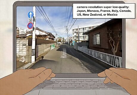
Look at the camera quality of the image. The camera quality can let you know what camera generation was used, allowing you to narrow down which country you’re in. If the camera resolution is super low-quality, there’s a good chance you’re probably in Japan, Monaco, France, Italy, Canada, the United States, New Zealand, or Mexico. Use this tool to identify the generation of camera used and what country you might be in.

Eliminate the countries that aren’t available to guess. While you can find unofficial street view pictures in every country, some don’t have official coverage or rarely appear in Geoguessr. When choosing the country you’re in, try to avoid the countries that don’t have official coverage unless you’re playing a map that includes them. Uncommon countries: Costa Rica, China, Cocos Islands, Lebanon, Qatar, Midway Atoll Rare countries: Antarctica, Vanuatu, British Indian Ocean Territory, Nepal, Afghanistan, Iraq, Egypt, South Georgia and South Sandwich Islands, Falkland Islands, Pitcairn Islands, Belarus Unavailable countries: Papua New Guinea, Vietnam, Myanmar, North Korea, Kazakhstan, Uzbekistan, Tajikistan, Turkmenistan, Iran, Armenia, Georgia, Azerbaijan, Turkey, Saudi Arabia, Omen, Yemen, Syria, Moldova, Kosovo, Bosnia, Paraguay, Suriname, Guyana, Venezuela, Cuba, Haiti, Jamaica, Belize, Honduras, Nicaragua, El Salvador, and Panama. In Africa, the only countries available are Botswana, Eswatini, Ghana, Kenya, Lesotho, Madagascar, Nigeria, Rwanda, Senegal, South Africa, Tunisia, and Uganda.
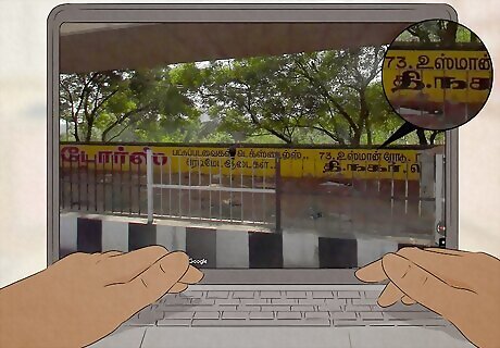
Identify the language written on street signs. Knowing what alphabets look like in different countries can help you narrow down where you are just based on the writing on street signs and advertisements. Use Geomastr’s alphabet tool to identify what language you see. This tool identifies key features that differ from similar languages. It also allows you to sort the languages by country and continent.
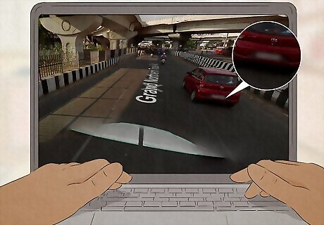
Look at the shape and color of the license plates. Most license plates are blurred out in the game, but you may see their general shape and colors, like yellow or white, that indicate the country. Compare the sign you see to GeoHint’s list of street signs to narrow down the country you’re in. For example, Portugal uses an EU-style long plate with a yellow bar on the right-hand side. Canada, the United States, Guatemala, Puerto Rico, Samoa, Virgin Islands, Guam, North Mariana Islands, Bolivia, Ecuador, Columbia, and Peru have taller plates than other countries.
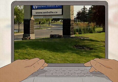
Identify the internet domain extension on ads and shop signs. If you see a sign along the road with a link to a website, look closely at the domain extension (like .com or .eu). Many extensions abbreviate the name of the country you’re in, which can give you a pretty good idea of where you are. For example, Botswana is .bw, Kenya is .ke, Uganda is .ug, Italy is .it, and Canada is .ca. For a full list of the abbreviations, see GeoHint’s domain tool.
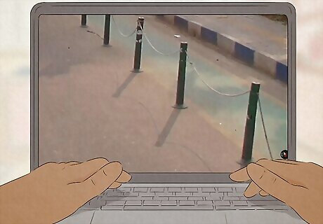
Study the specific bollards or road markers in each country. Bollards are posts designed to prevent vehicles from driving off the road. Each country has its own bollard design with different materials and colors. Look at the bollards in GeoHint’s list to find which country you’re currently in. For example, Mongolia is the only country with white bowling-pin-shaped bollards with two red stripes along the top portion.
Move in the opposite direction that the Google car is going. Most Google Street View vehicles travel by highway to the location they’re photographing. If you’re playing a game mode that allows you to move, go in the opposite direction that the car is traveling to find the highway or major road. Similarly, if you’re on a hill or mountain, try to travel downhill to find nearby settlements and cities. If you aren’t moving, look for signs that tell you the direction of the nearest highway or major road. Then, guess a position along a road that branches off from that highway.
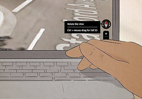
Use the compass to pinpoint your location on the road. Once you figure out the country you’re in and what road you’re on, use the angle of the road to pinpoint exactly where you are. Face north and look directly down at the ground. Look at the map and find a section where the angle of the road matches the angle of a section on the map. Click on the gear in the lower right-hand corner and toggle the “Classic Compass” button off. This will make the compass a scroll wheel at the top of the screen so you can more accurately face north.

Listen to your instincts and try to avoid overthinking your guess. If a country or location pops into your mind immediately, trust your instincts. You might be getting subconscious clues that the rational side of your mind can’t quite place, which can help you beat the game faster than if you tried to gather evidence to support them. If you want to make your guesses faster, listening to your intuition is a great way to start. However, the best way to improve your skills is to practice over and over again.
Geoguessr Game Modes

Streaks In the U.S. and Country Streak modes, you only have to identify the country or state you’re in. The challenge is to see how many countries or states you can guess correctly in a row!
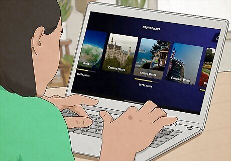
Classic Classic mode is the original game mode in Geoguessr. You’ll be placed in a random location that you have to guess by placing a marker on the map in the lower right corner. There are also Events on the Geoguessr home page you can play in any game mode.
Explorer In Explorer Mode, compete against strangers or challenge your friends to see who can guess the closest to the location. You’ll get 5 different locations all within the same country. Increase the difficulty by setting movement, zoom, or time limit restrictions.

Duels You and another player are given 6,000 health points and have to compete against each other to see who can guess the closest to a location. When you or your opponent makes a guess, it starts a 15-second timer that the other person has to guess within or they lose health points. To win, you have to reduce your opponent’s health points to 0. The damage you inflict increases by 0.5x each round. Team Duels is the same concept, except that you play with up to 19 other players instead of just 1.

Bulls-Eye This new team-based game mode is made for 2 to 6 players. The goal is to find the random location your team is given. Everyone makes a guess, and the guess that’s closest to the location counts towards your score. Try to get a high score within the 5 untimed rounds to win!
Playing & Winning Geoguessr

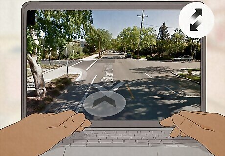
Look at your surroundings and try to guess your location. As soon as you start a game in Geoguessr, you’ll drop into a random location that was captured by Google Maps. Click the arrows on the ground to move around and click and drag the screen to look at your surroundings and figure out where you are in the world. In the bottom left corner of the screen, the “+” and “-” buttons zoom you in and out, the flag button returns you to where you first appeared (your checkpoint), and the teardrop sets the checkpoint to where you are currently. The arrow button is an “undo” button. You can also move around with the “W,” “A,” “S,” and “D” keys.
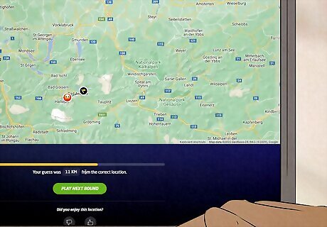
Drop a pin as close to the location as possible to win. The goal of Geoguessr is to guess as close to the location you’re dropped in as possible. The points you earn are based on your proximity to the location. However, the distance you are has a bigger impact the closer you are. Guesses below 25 m (82 ft) always count as a perfect score. The map you play also impacts the score—choosing the wrong location on a world map tends to cost you more than choosing the same distance away on a country’s map. The highest score you can get per round is 5,000 points. A perfect game of Geoguessr is 25,000 points.


Comments
0 comment