

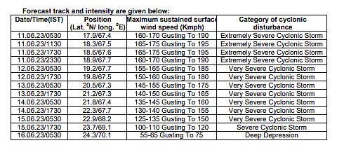
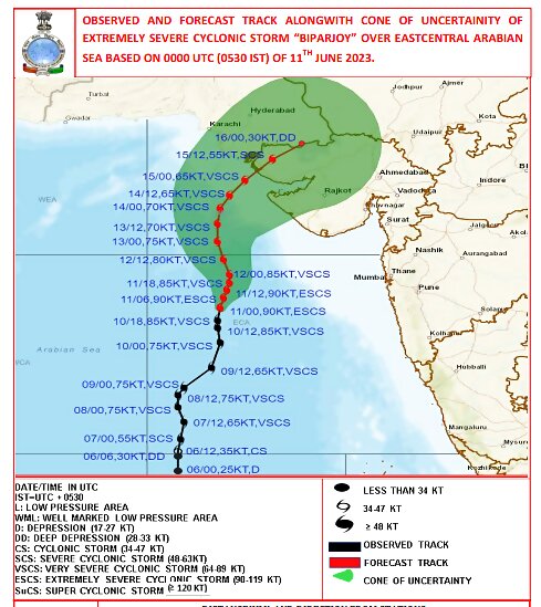
The Very Severe Cyclonic Storm Biparjoy, which has now travelled far north of the Arabian Sea, could make a landfall between Gujarat’s Mandvi and Pakistan’s Karachi, warned the India Meteorological Department (IMD) on Sunday.
The cyclone that formed in the east-central Arabian Sea on Wednesday evening is currently raging as an Extremely Severe Cyclonic Storm, with winds gusting up to 190 kmph in the seas.
“However, its intensity is likely to reduce marginally by the time it makes a landfall on Thursday. We are expecting a landfall between Mandvi (Gujarat) and adjoining Karachi (Pakistan) coast around Thursday afternoon. We have issued warnings for heavy rainfall, storm surges and high winds of about 125-135 kmph in the coastal districts,” senior IMD scientist Monika Sharma told News18.
Updating its forecast, the weather department has now issued a Yellow Alert for Gujarat and Kutch, with heavy rainfall predicted for districts of Kutch, Devbhumi Dwarka, Porbandar, Jamnagar, Rajkot, Junagarh and Morbi, including the Gulf of Kutch. Storm surge of about 2 m above the astronomical tide is likely to inundate the low-lying areas of above districts during the time of landfall, warned the department.
As of Sunday morning, the cyclone was located about 580 km west-southwest of Mumbai, 480 km south-southwest of Porbandar, 530 km south-southwest of Devbhumi Dwarka, 610 km south-southwest of Naliya and 780 km south of Karachi (Pakistan).
According to the IMD, it is very likely to move nearly northward till June 14 morning, then move north-northeastwards and cross Saurashtra and Kutch and adjoining Pakistan coasts between Mandvi (Gujarat) and Karachi (Pakistan) around noon of June 15 as a very severe cyclonic storm with maximum sustained wind speed of 125-135 kmph gusting to 150 kmph.
HEAVY RAINS, STORM SURGES
The intensity of rainfall would increase with heavy to very heavy rainfall at a few places and extremely heavy falls at isolated places very likely over Kutch, Devbhumi Dwarka and Jamnagar and heavy to very heavy rainfall at a few places over Porbandar, Rajkot, Morbi and Junagarh districts of Gujarat on June 15.
Sea conditions are likely to be rough to very rough till June 14 evening and high to phenomenal thereafter till June 15 noon and improve thereafter. Storm surge of about 2 m above the astronomical tide is likely to inundate the low-lying areas of above districts during the time of landfall.
The high winds and rainfall could lead to total destruction of thatched houses/ extensive damage to kutcha houses, according to the IMD. There could be some damage to Pucca houses as well. Minor disruption of railways, overhead power lines and signalling systems is also expected apart from widespread damage to standing crops, plantations, orchards, falling of green coconuts and tearing of palm fronds.
The department has advised total suspension of fishing operations over east central and adjoining west central Arabian Sea till June 15.
RAPIDLY INTENSIFYING
Cyclones in June in the Arabian Sea are not that unusual. But the warm sea surface temperatures have been fuelling intense storms in the Indian Ocean, with the cyclones intensifying faster than ever before.
In case of Biparjoy, the low pressure area formed over southeast Arabian Sea on the evening of June 5 and intensified into a depression within 12 hours. By around 11.30 am on June 6, it had intensified into a deep depression over southeast and adjoining the east-central Arabian Sea. By 5.30 pm on June 7, it turned into a cyclonic storm. And within the next 12 hours, it became a ‘very severe’ cyclonic storm over the same region. On Saturday, the intensity increased to an Extremely Severe Cyclonic Storm.


Comments
0 comment